



Northern Iowa drought persists despite wetter-than-normal August statewide

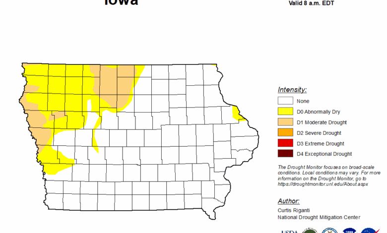
DES MOINES, Iowa — Iowa finished August wetter than normal overall, but drought conditions continue across northern and western portions of the state, according to the latest Iowa Water Summary Update.
Statewide precipitation totaled 4.79 inches during August, which was 0.66 inches above normal. However, rainfall was unevenly distributed, with much of Iowa receiving near- to below-normal precipitation.
Northwest Iowa experienced some of the largest rainfall deficits, with precipitation running between 1 and 3 inches below normal in some areas.
An area of severe drought developed in western Iowa during August, keeping a drought watch in effect for northwest Iowa and triggering a new drought watch for central Iowa, according to the report.
Southern and northeastern Iowa generally maintained more stable conditions due to above-normal precipitation.
Low surface soil moisture was reported in portions of western and eastern Iowa, while central Iowa remained wetter. Streamflow levels across the state were largely classified as normal.
According to Iowa’s Drought Plan, drought watches are currently in effect for the northwest and central drought regions. The state’s other three drought regions remain under a normal designation.
The latest U.S. Drought Monitor shows nearly 26% of Iowa experiencing abnormally dry conditions, with nearly 9% of the state classified in moderate drought.
“While recent rainfall brought welcome relief to parts of Iowa, persistent dryness in the northwest keeps drought conditions active in those areas as we move into the fall,” Iowa Department of Natural Resources Environmental Specialist Jessica Reese McIntyre said.
August temperatures also warmer than normal
Temperatures across Iowa averaged 71.9 degrees during August, about 0.9 degrees above normal.
The warmest conditions were reported across central and northwest Iowa.
August 2026 tied 1921 and 2020 as the 75th-warmest August on record in Iowa. It also ranked as the state’s 36th-wettest August on record.
Drought could persist into fall
The National Weather Service Climate Prediction Center’s September outlook shows an increased chance of above-normal temperatures across Iowa.
For precipitation, the outlook calls for equal chances of above-normal, below-normal or near-normal rainfall.
The seasonal outlook through October indicates drought conditions across western and northwestern Iowa are likely to persist.
The Iowa Water Summary Update is prepared by staff from the Iowa DNR, Iowa Department of Agriculture and Land Stewardship, IIHR—Hydroscience and Engineering and the U.S. Geological Survey in collaboration with the Iowa Department of Homeland Security and Emergency Management.
More information is available through the Iowa DNR’s Water Summary Update.
Stay Connected with North Iowa Now
Add North Iowa Now as a preferred source on Google to see more local news, weather, and sports in your feed.
Follow us on Facebook for breaking news, severe weather alerts, sports, and more.
