



Iowa Crop Report: Corn, Soybean Conditions Hold as Rain Soaks State

DES MOINES — A wet start to September has eased drought conditions across western Iowa, but persistent rain is likely to limit fieldwork in the coming week, Iowa Secretary of Agriculture Mike Naig said in the state’s weekly crop progress report released Monday.
Farmers had 4.5 days suitable for fieldwork during the week ending Sept. 13, according to the Iowa Crop Progress and Condition Report from the USDA National Agricultural Statistics Service. That’s two days fewer than the same week last year, when 6.5 days were available.
“A wet start to September has helped ease drought conditions across western Iowa,” Naig said. “Another wet week ahead may limit fieldwork across much of the state. Farmers will likely use the opportunity to tackle other important work around the farm, including getting equipment ready for harvest.”
Topsoil moisture was rated 80% adequate and 7% surplus statewide, with 13% rated short or very short, the report showed. Subsoil moisture was rated 73% adequate and 5% surplus, with 22% short or very short.
Corn reaching the dent stage stood at 89%, on par with last year, while 38% of the crop had reached maturity, 7 percentage points behind last year’s pace. Harvest has begun, with 2% of corn cut, 1 percentage point behind last year. Corn condition was rated 76% good to excellent.
Soybeans were further behind normal timing, with 22% of the crop dropping leaves, 10 percentage points behind last year. Soybean condition was rated 74% good to excellent. Pasture condition was rated 64% good to excellent.
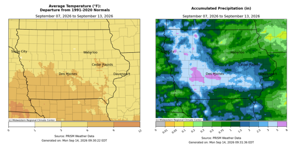
State Climatologist Justin Glisan, in the report’s accompanying weather summary, said broad areas of Iowa saw 400% to 600% of normal rainfall during the period, accompanied by unusually warm temperatures. The statewide average temperature was 71.2 degrees, 5.5 degrees above normal.
Two rounds of thunderstorms brought heavy rain to the state during the week. The first, moving through western and central Iowa Sept. 6-7, dropped 2 to 4 inches across west-central Iowa, with Guthrie Center in Guthrie County recording 4.79 inches. A second, more intense system Sept. 8-9 produced training thunderstorms and severe weather, including wind damage in Polk County, according to the report. Nearly 100 stations recorded at least 2 inches of rain, with close to 20 stations topping 4 inches in central Iowa. Des Moines recorded 5.87 inches and Norwalk in Warren County recorded 5.21 inches. Numerous flash flood warnings were issued as the system approached the Iowa-Missouri border.
The statewide average rainfall for the week was 2.05 inches, more than double the normal of 0.84 inch, according to the report. Weekly totals ranged from 0.23 inch in Nora Springs in Floyd County to 7.76 inches in Guthrie Center.
Shenandoah in Page County recorded the week’s high temperature, 100 degrees on Sept. 8, 19 degrees above normal. Spencer Municipal Airport in Clay County recorded the week’s low, 44 degrees, seven degrees below normal.
Stay Connected with North Iowa Now
Add North Iowa Now as a preferred source on Google to see more local news, weather, and sports in your feed.
Follow us on Facebook for breaking news, severe weather alerts, sports, and more.
